


"Misdirection is the most important part of any great trick, Mister Sakyo. While they look at the pretty colors, we make the real magic happen."
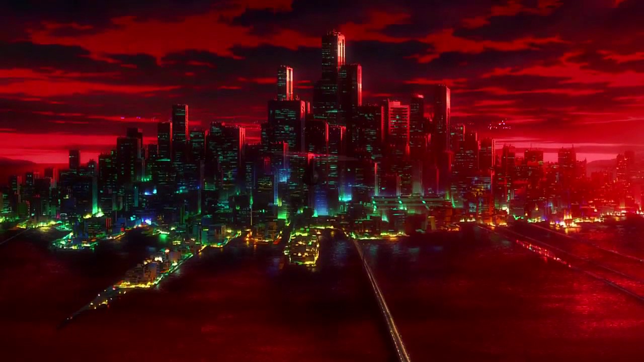
Ketsuekikawa is a small city located West of Mt. Tokusenjo and Oshima Island on the fictional island of Ōkina Akajima. While small, the city tends to be successful and relatively lucrative as a seasonal vacation area and research center for marine biologists. The season aspect of the city is in part due to the springs from its mountainous areas and hiking traits, but more so is more so because of the four-day period in late July (normally between the 22nd and the 28th, varying by the year) in which the Ketsue Channel is brightly illuminated by the mid-morning until mid-evening. During this time, the water can be seen glowing bright hues of orange, purple, pink and red. Swimming in the channel during these times is considered good luck for the year with individual colors traditionally representing what type of luck one might want: red represents personal passions, pink represents love, purple is financial success and orange is better health. The marine research going on is very closely related in that unique breeds of algae and species of bio-luminescent fish live in the area and are believed to be related to the ancient traditions of the Ketsue Channel.
|
Contents 1. History
1.1 Founding 1.2 Rise as a Tourist Attraction 1.3 Advent of Marine Biology 1.4 Red River Festival
2. Geography 1.1 Inner City 1.2 Suburbs 1.3 Nature Trails 1.4 Ketsue Channel 3. Places of Interest
3.1 Sarayashiki Junior High 3.2 Kasanegafuchi Junior. High
|
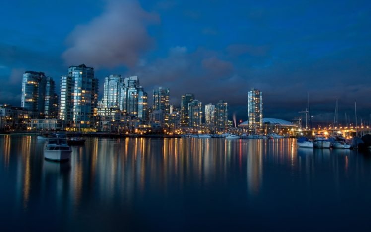
| Ketsuekikawa (1992) |
|---|
|
| Mayor Noboru Saitō |
Miyagi Prefecture, Tōhoku, Japan Population 42, 246 Area 291.88 km2 Humid Climate
|
Tree Japanese Maple Flower Azalea Bird Ruddy Kingfisher Fish Pagrus Major
|
History
Founding
While their has always been a native population to the island as far back as history has recorded, the first important uses of the island were as a relegated off-short prison. The Northern section of the island was once used as a labor camp due to its fertile lands and prisoners could work off their crimes. During the Warring States period, the island gained some level of independence to assist its allies and eventually developed into a minor house. This minor house, however, was founded primarily by criminals and with its out-of-the-way placement, illegal trade became the primary source of income for the island. The fortune brought to the island eventually gave birth to a city, but since then, the city was razed to the ground near the end of the period and rebuilt. This second city is the one known as Ketsuekikawa.
The illegal trade only became more rampant in Ketsuekikawa, especially as it earned fame for the local traditions held yearly. Through the different eras and generations, it fell into different hands, but only continued to expand. Trade was made more discrete over time as was criminal activity, allowing the city to be ushered into the modern age without question. Regardless, the last several centuries of the island involved constant adaptation and cover-ups from government officials to preserve the illegal fortunes being made on the island.
Rise as a Tourist Attraction
Kestuekikawa always existed as a seasonal tourist attraction, but after World War II, the city became more well-known to the public. This is primarily because of WWII propaganda using the bright red depictions of the Ketsue Channel to describe Japan as a "hellish land with rivers of blood" only for the sheer beauty of the land to make it world-renown after the fact. In the years following the restructure of Japan, Ketsuekikawa went from roughly eight thousand tourists per year to upwards of thirty-five to forty. It is is literally known to double in size and the revenue from this has allowed it to expand its inner cities and create structured "packages" for tourists to allow the sheer volume of visiting during the seasonal periods. While rarely making it to a top ten, the Ketsue Channel is often listed in the top 25, 50, and 100 places to visit in the world.
Advent of Marine Biology
Near the beginning of the seventies, marine biologists and environmental scientists more seriously sought to understand the phenomenon of the Ketsue Channel. It is not entirely understood what triggers the changes in colors, but it is believed to be some type of environmental stimuli to unique algae or microorganisms in the water. Species within the bay the Ketsue Channel flows into are often considerably different and more colorful than their nearby cousins. Countless generations have sworn by the rejuvenating properties of the waters and scientists have already made advancements with the compounds provided. While difficult to manufacture due to the low quantity of supply, researchers have confirmed cures for acne, baldness, and even powerful albeit temporary arthritis relief with objective data showing lower rates of inflammation. These studies have continued to result in copious amounts of funding being poured into the research laboratories.
Red River Festival
A complete misnomer, the Red River Festival is the highlight of the yearly activities in Ketsuekikawa. Not only do the waters glow several other colors (although red is most prominent), the Ketsue Channel is not technically a river. Regardless, the Festival brings the entire island to life with various parties everywhere. Entire sections of the Ketsue Channel are divided up to try and pour in tens of thousands of people into the waters during the four day period. The word "glow" is important to use here because the waters both reflect and generate their own light. It is most bright on the first day and by the final day, these lights fade over several hours.
Inner City
While Ketsuekikawa has many rural and beautiful scenic areas, the most inner portion of the city is a compact metropolis for the wealthy and tourists. The most-high end apartments, hotels, political buildings, clubs, bars, restaurants, etc. are found here. Notably, there are very few schools in this area and the few present are often lower-grade schools for toddlers. This portion of the city is booming, especially during tourist season, and the money i pulls in fuels the economy of the city for the remainder of the year. While the rest of the city and island are often integrated, this portion of it is the most man-made, metallic, and rigid. The tall buildings and large streets of this area nearly allow for the island to double in population during its heaviest seasons.
Suburbs
The largest portion Ketsuekikawa is distinctively the suburban areas where most of the year-long citizens live. The rule of thumb for the suburbs is quite simple: the further away from the inner city one is, the worse off one has it. This isn't entirely true as the Eastern section of the island contains the more mountainous areas with the springs and the Ketsue Channel and the northern section of the island is slightly agricultural, but the rule of thumb is still fairly well respected. The only other exceptions to this are the docks on either side of the island, but even then, immediately traveling from the guarded docks can even be dangerous depending on the delinquents and potential gangs. It's well-understood that the eastern and southern portions of the island are fairly dangerous with high crime rates, but these statistics are often suppressed for the sake of tourism. Most schools, hospitals, and other important buildings tend to be located closer to the inner city with rougher or less prestigious schools being located further out.
Nature Trails
While the Northern half of the island has small farms due to the enriched soil above the rough terrain, the Eastern portion of the island has many beautiful trails with flowering plants of all sorts leading to underground springs, some cool, some hot. The springs are often considered an oddity due to their placement and the relatively low altitude of even the highest areas on the island, but their cool, calming waters or potentially steaming baths hold true despite questions. Notably, some of the cold pools illuminate during the festivals in July, but never the hot ones. Because different pools glow each year, it is considered the best of luck and even rejuvenating to soak in these waters during this time. This tradition has become one of the most prominent as access to the cold springs is blocked off during this time in favor of a fee to get in.
Ketsue Channel
Cutting through the East section of the island and originating from the large mouth of an east-facing, underground cave is the Ketsue Channel. The main body of this channel flows directly eastward, but it is also fed by several small tributaries from the mountainous terrain. It feeds into a small bay full of all forms of unique aquatic life. The areas surrounding this bay, particularly to the North, are often where research laboratories are located. On the southern half of this east-sided bay is another set of docks. The entire length of the Ketsue Channel is kept untouched by up to 20 meters in either direction with no buildings allowed generally for 40-50 meters. This is in part to preserve the ecosystems, but also due to the large influx of people that line up and take turns getting in the water during the seasonal illumination.
Sarayashiki Junior High
The Sarayashiki High School District is rated as the top public school in Ketsuekikawa and is located just outside the edges of the inner city. It is one of the "big three" schools that kids from the inner city attend, and is most well-known for its high academic performance. It is the direct rivalry with the nearby school district of Kasanegafuchi in both academics and in the streets.
Kasanegafuchi Junior High
The Kasanegafuchi High School District is rated only eighth in the public school rankings, but is ranked second in academic marks under Sarayashiki. It is located Southwest of the aforementioned school district and is a considerably larger school with nearly twice the population due to being deeper in the more-populated suburbs. It has a deep-rooted rivalry with Sarayashiki, but often due to its placement further away from the inner city and lower in the social echelons more so than its marks.
Last edited: